Malheur River Basin Sees Historic Flooding
The 2025 water year has brought historic conditions to the Malheur River Basin, including near record-level flooding, elevated runoff, and significantly above-average precipitation and snowpack.
River Reaches Historic Levels
On February 25, the Malheur River reached a crest of 23.57 feet at the U.S. Geological Survey (USGS) gauge in Vale. This marked the third highest recorded stage at that location, surpassing the major flood stage threshold of 23.0 feet. The only higher crests occurred in 1957 (24.58 feet) and 1982 (23.8 feet), according to the National Water Prediction Service.
Flooding conditions were observed throughout much of the basin, including widespread water over agricultural fields, localized damage to infrastructure, and disruption to transportation along Highway 20. In some areas, crews reported three to five feet of water covering roadways and the highway was closed for several days while ODOT crews worked to clear it.
Contributing Factors: Snowpack and Precipitation
Data from the Natural Resources Conservation Service (NRCS) shows that the Malheur River Basin entered 2025 with well-above-normal snowpack and precipitation. As of early February, the basin had received 118% of normal water year-to-date precipitation, and snow water equivalent (SWE) levels reached approximately 150% of the 1991–2020 median.
These conditions contributed to increased runoff and flood risk as warmer temperatures and rainfall led to snowmelt across higher elevations.


Reservoir Status and Management Actions
Reservoirs in the region were holding near-capacity storage levels as of April 2025:
Beulah Reservoir: 92% full
Warm Springs Reservoir: 93% full
Bully Creek Reservoir: 99% full
Unity Reservoir: 98% full
Owyhee Reservoir: 99% full
On Feb 27, the U.S. Army Corps of Engineers (USACE) and Bureau of Reclamation began controlled releases from Warm Springs, Agency Valley, and Bully Creek dams. These releases were part of a broader flood risk management strategy aimed at balancing reservoir refill with downstream flow moderation.
Water managers have indicated that releases will continue to be adjusted based on current inflows, snowpack conditions, and local weather patterns. Although much of the low elevation snow was melted off with this event, there was nearly record setting snowpack above the reservoirs. Reservoirs managers resumed releases in anticipation of future snow melt and runoff entering the reservoirs. These releases were intended to reduce the risk of future high peak flows during the spring runoff season, while also not exacerbating downstream flood damages from naturally occurring runoff.
Ongoing Response
Following the peak in late February, river levels have receded to moderate flood stage, but damage assessment and recovery efforts are ongoing. Malheur County declared a local state of emergency in response to infrastructure impacts and economic losses. The county requested state-level assistance through the Oregon Disaster Recovery Framework.
On March 18, Governor Tina Kotek issued a statewide emergency declaration covering multiple counties, including Malheur, due to flooding and landslides occurring from February 24 to March 18. The declaration enables coordination with the Oregon Department of Transportation and access to federal resources to address an estimated $10 million or more in damages to the federal-aid highway system and other public assets. It does not allocate funds for other uses or recovey outside of ODOT.
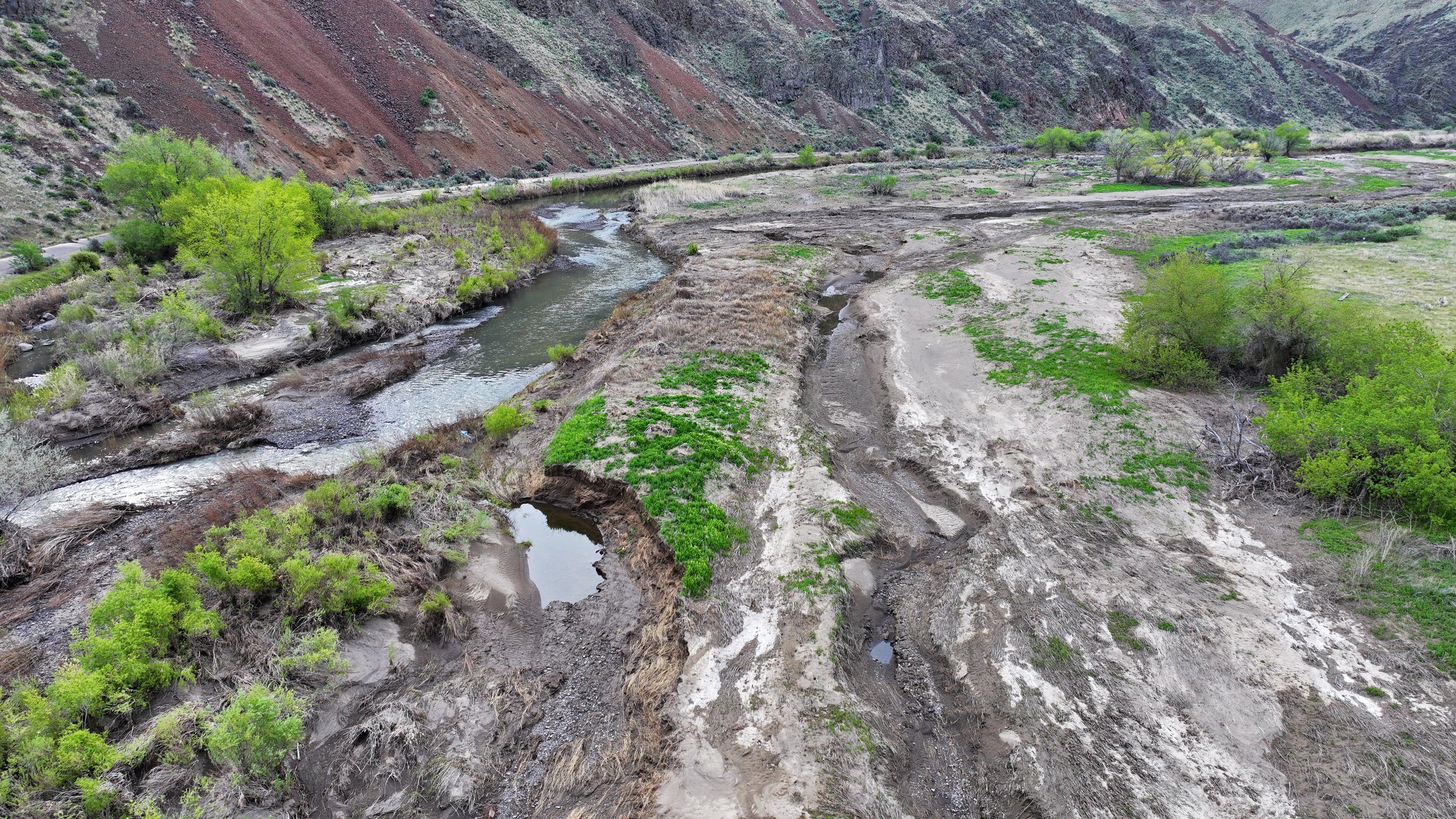
Impacts
In addition to infrastructure damage, the floods have impacted the Basin’s watershed and agricultural economy. Riverbanks were eroded, channels shifted, and floodwaters carried debris onto farmland. As conditions stabilize, restoration and mitigation efforts will be critical.
The Malheur Watershed Council is actively working to support landowners and partners with resources and guidance for recovery and watershed restoration. Those affected are encouraged to reach out for assistance.
Data Resources: For those tracking water and flood conditions, the following resources provide updated information: